
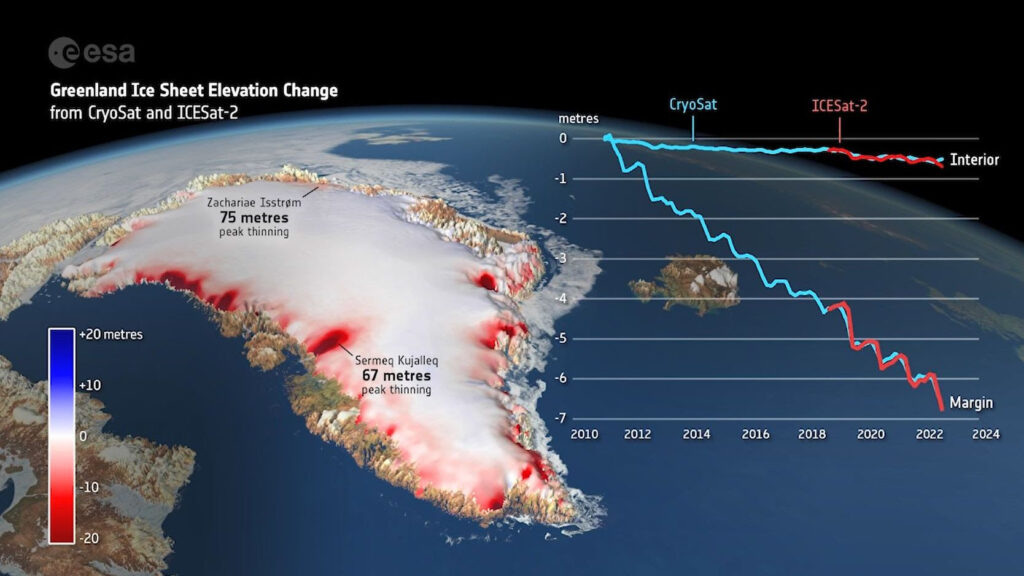
The collaboration between ESA’s CryoSat-2 and NASA’s ICESat-2 has delivered a groundbreaking first: joint measurements of Greenland Ice Sheet thickness changes. Academics at Northumbria University, in partnership with the UK Centre for Polar Observation and Modelling (CPOM), have played a pivotal role in this effort, which provides critical insights into the impacts of global warming.
Combining Forces for Precision Tracking
Greenland’s Ice Sheet, an essential regulator of global sea levels and weather patterns, is melting at an alarming rate. Between 2010 and 2023, the Ice Sheet thinned by an average of 1.2 meters, with margins experiencing over five times greater thinning at 6.4 meters.
By combining radar technology from CryoSat-2 with laser measurements from ICESat-2, scientists achieved unprecedented accuracy in tracking ice loss, with results aligning to within 3%. This synergy enables more reliable data, ensuring that polar monitoring can continue even if one satellite mission fails.
“This collaboration represents an exciting step forward,” said Tommaso Parrinello, CryoSat Mission Manager at ESA. “Aligning our data with ICESat-2 has opened new avenues for precision and insight.”
Key Findings: Alarming Thinning Rates
The 13-year survey revealed the Ice Sheet lost a staggering 2,347 cubic kilometers of ice—equivalent to the volume of Africa’s Lake Victoria. Notable findings include:
- Hotspots of Melting: Jakobshavn Isbræ (Sermeq Kujalleq) and Zachariae Isstrøm saw extreme thinning of 67 meters and 75 meters, respectively.
- Critical Years: Record-breaking losses of over 400 cubic kilometers occurred during the hot summers of 2012 and 2019.
- Global Impact: Greenland’s melting ice is disrupting ocean circulation and global weather systems, with far-reaching consequences for ecosystems and communities.
Lead researcher Nitin Ravinder from CPOM highlighted the value of these advancements: “As ice sheet mass loss is a key contributor to global sea level rise, this is incredibly useful for the scientific community and policymakers.”
The Technology Behind the Mission
CryoSat-2 uses radar altimetry, capable of penetrating cloud cover and measuring ice surface height. ICESat-2 complements this with laser altimetry, providing precise surface readings but requiring clear skies. Together, they offer a comprehensive view of ice sheet dynamics.
The Cryo2ice campaign, initiated in 2020, marked a turning point by aligning CryoSat-2’s orbit with ICESat-2 for synchronized data collection. This innovative partnership has allowed researchers to measure snow depth from space, enhancing their ability to monitor both sea and land ice with unprecedented accuracy.
“This alignment has unlocked new potential for tracking ice changes,” said Thorsten Markus, ICESat-2 project scientist at NASA. “We can now fully exploit the complementary nature of these missions.”
Preparing for a Warmer Future
The findings underscore the urgent need for accurate data to inform climate policy and adaptation strategies. CPOM’s efforts are integral to this goal, using satellite observations to monitor polar changes and numerical models to predict future developments.
As global warming accelerates ice loss, the study highlights the importance of sustained satellite missions. Both CryoSat-2 and ICESat-2 continue to provide vital data, while the upcoming CRISTAL mission is expected to further enhance our understanding of polar ice.
“This is a critical step toward mitigating the impacts of climate change,” said Parrinello. “Our work serves both scientists and policymakers in their efforts to safeguard the planet.”
About CPOM
CPOM, based at Northumbria University, is a collaboration among six UK universities and the British Antarctic Survey. It is funded by the National Environment Research Council (NERC) to support polar research and global climate planning.