

Introduction to Utah’s Mighty Five
Five parks. One week. And a landscape so extreme it looks like a different planet. Southern Utah holds one of the greatest concentrations of geological wonder on Earth, and the road trip that threads Arches, Bryce Canyon, Canyonlands, Capitol Reef, and Zion together into a single journey is genuinely one of the best drives in the world. A 2020 peer-reviewed study published by the Utah Department of Public Safety found that drought has a statistically significant negative effect on visitor numbers at Arches, Canyonlands, and Capitol Reef National Parks, though notably it has no significant effect on visitation to Bryce Canyon, suggesting that planning around drought conditions may matter more at some parks than others.
Not “one of the best in America.” In the world.
Exploring the Beauty of Utah National Parks
Here’s the thing about planning a road trip through Utah national parks: the photos don’t lie, but they do fail. No image captures the scale. Standing at the rim of Canyonlands and watching the Colorado River glint 2,000 feet below you, or hiking into the slot canyons of Zion while walls close in on both sides until the sky becomes a thin ribbon of blue above your head, those are physical experiences. You feel them in your knees and your chest, not just your eyes.
The journey usually starts at Zion, because Zion is the kind of opener that grabs you by the collar. Towering sandstone cliffs in shades of cream, rust, and burnt orange rise straight from the canyon floor, and the Virgin River threads through the middle of it all. Day one, and you’re already rewriting your sense of what “big” means.
Then comes Bryce Canyon. Technically not a canyon at all, it’s a series of natural amphitheaters eroded into the Paunsaugunt Plateau, packed with hoodoos: those tall, thin spires of red, orange, and white rock that nobody ever quite believes are real until they’re standing among them. Bryce Canyon sits at elevations between 8,000 and 9,100 feet, which means it can snow here while Zion, just 50 miles away as the crow flies, bakes at 90 degrees. The light at sunrise turns the whole amphitheater a colour somewhere between apricot and fire, and if you’re there for it, you’ll understand why people drive across continents to see it.
Capitol Reef comes next, quieter than its neighbours but no less dramatic. The Waterpocket Fold, a hundred-mile-long wrinkle in the Earth’s crust, runs straight through the park and creates a landscape of sculpted canyons, white domes, and red cliffs that feels entirely unlike anything else in Utah. It also has fruit orchards. Actual working fruit orchards in the middle of the desert, planted by Mormon pioneers in the 1880s, where you can pick cherries or apples depending on the season.
Canyonlands is where the scale becomes almost incomprehensible. The Colorado and Green Rivers carved this place over millions of years, and what they left behind is a sprawling maze of mesas, buttes, and canyon systems covering 337,598 acres. The park divides into three districts: Island in the Sky, the Needles, and the Maze. The Maze, true to its name, is one of the most remote and difficult to navigate places in the continental United States.
And then there’s Arches. Over 2,000 naturally formed stone arches within a single park boundary, the highest concentration anywhere on Earth. Delicate Arch, the one on Utah’s license plate, stands 46 feet tall and 32 feet wide and has been eroding for the last 60,000 years. Every visit to Arches feels like borrowed time in the best possible sense.
These formations won’t last forever. You should go now.
A road trip through all five Utah national parks in one week is ambitious but absolutely doable. The parks sit within a roughly 300-mile circuit in southern Utah, and the drives between them are themselves part of the adventure. Red rock country doesn’t stop being spectacular just because you’re in a car.
Start Your Journey at Zion National Park
Zion is the right place to begin. It’s the most visited of the Utah national parks, pulling in around 4.7 million visitors a year, and that number tells you something. But even with those crowds, particularly in peak summer months, Zion delivers. The place is simply too dramatic to be diminished by company.
The park covers 229 square miles of canyon country in southwestern Utah, anchored by Zion Canyon itself: a narrow gorge up to half a mile deep, carved by the Virgin River over millions of years. The mandatory shuttle system, which runs from spring through fall, keeps private vehicles out of the main canyon and actually makes the experience better. You step off the bus, and the walls are right there.
Zion national park rewards every type of traveller. Serious hikers can push themselves on multi-day backcountry routes. Families with young kids can walk the paved Riverside Walk alongside the river. Photographers come for the morning light on the Watchman formation.
Everyone finds something.
Must-See Trails and Views in Zion
The trail that defines Zion, and probably defines Utah hiking for most people, is Angels Landing. It’s a 5.4-mile round trip that gains 1,488 feet of elevation, and the final half-mile follows a narrow sandstone ridge where the drop on both sides is essentially vertical. Chain handholds bolted into the rock guide you along. The National Park Service introduced a permit system in 2022 to control the crowds on that final section, so plan ahead and book early.
The views from the top, straight down into Zion Canyon in every direction, are worth every difficult step up.
But Angels Landing isn’t even Zion’s only world-class trail. The Narrows is something else entirely. You start at the end of the Riverside Walk and then you wade into the Virgin River itself, hiking upstream through a slot canyon where the walls are 1,000 feet high and sometimes only 20 feet apart. Rental wetsuit gear from Springdale is worth it outside of summer, when the water runs genuinely cold.
Inside the Narrows, you lose all sense of time. The light shifts constantly as it angles down between the walls, and hanging gardens of moss and fern cling to the wet rock. It’s one of the most immersive hiking experiences in the national park system.
Observation Point offers the best elevated view in the park, arguably better than Angels Landing because you’re looking down at Angels Landing from above. The trail is 8 miles round trip with 2,148 feet of elevation gain, steeper than Angels Landing overall but without the exposure on the ridgeline. The final viewpoint sits at 6,508 feet. Sunrise up there, with the canyon filling slowly with light below you, is the kind of thing you don’t forget.
For something quieter, the Hidden Canyon Trail takes you through a narrow gorge accessible via a ledge trail with some modest chain sections, rewarding you with a secluded sandstone canyon full of hanging gardens and solitude. On a busy Zion day, it’s remarkable how quickly the crowds thin out once you commit to the less obvious trailheads.
One practical tip worth knowing: the Zion-Mount Carmel Highway, which exits the park through the east entrance, is one of the most spectacular drives in the southwest. The 1.1-mile tunnel (built in 1930) gives way to a completely different landscape on the east side, all slickrock domes and checkerboard mesas. If you’re heading toward Bryce Canyon on your road trip, you’ll drive this route. Take your time on it.
Camping and Accommodation Options in Zion
Zion national park has two main campgrounds: Watchman and South Campground. Watchman, near the south entrance, is the larger of the two with 176 sites and some electrical hookups for RVs. It operates year-round and books up months in advance for spring and fall visits. South Campground is tent-only and sits right along the Virgin River, which sounds idyllic, and mostly is.
Both campgrounds put you inside the park, which means you wake up surrounded by canyon walls rather than a motel parking lot.
Reservations at Watchman open six months in advance on recreation.gov. If you’re planning a spring or fall trip, set a calendar reminder and book the moment that window opens. Summer dates go fast too, though the heat in Zion’s canyon bottom in July and August is serious. Temperatures regularly hit 105 degrees Fahrenheit on the canyon floor, and shade is scarce on exposed trails.
Zion Lodge, the only accommodation actually inside the park, offers motel rooms and cabins managed by Forever Resorts. It’s expensive by motel standards and books up well in advance, but waking up with the canyon cliffs literally outside your window has a value that’s hard to quantify. The lodge sits next to the shuttle stop for the Grotto trailhead, giving you instant access to several of the park’s best hikes.
Springdale, directly outside the south entrance, is the town that grew up to serve Zion visitors, and it does the job well. You’ll find restaurants ranging from casual burger joints to genuinely good sit-down dining, gear shops, tour operators, and a wide range of accommodation from budget motels to boutique hotels with canyon views. The town shuttle connects Springdale to the park’s south entrance for free, so you don’t need to drive or fight for parking. For a one-week road trip through the Mighty Five, Springdale makes an excellent first-night base.
Discover the Wonders of Arches National Park
Arches national park sits just outside Moab in southeastern Utah, about four hours northeast of Zion on the most direct route. On a Mighty Five road trip, many people visit Arches and Canyonlands together, since they’re only 30 miles apart. That’s the right call. Moab serves as the hub for both parks, and it’s a genuine adventure town with good food, gear shops, and an energy that matches the landscape around it.
The park covers 76,519 acres of red rock desert on a high plateau above the Colorado River. Entrada Sandstone, deposited as desert dunes 150 million years ago and then buried, compressed, and eventually exposed by erosion, forms most of what you see. Salt deposits far underground cause the rock above to shift and fracture along vertical lines, and it’s in those fractures that arches form. The process takes millions of years.
The results are ridiculous.
Over 2,000 arches. One park. It’s genuinely staggering.
Iconic Landmarks in Arches National
Start with Delicate Arch, because you have to. The 3-mile round-trip hike gains 480 feet across open slickrock, and the final approach curves around a sandstone fin before the arch appears suddenly, spectacularly, framing the La Sal Mountains behind it. At 46 feet high and 32 feet wide, Delicate Arch is freestanding, meaning no wall behind it. Just arch, sky, and mountain.
The hike is best done early morning to beat the heat and the crowds, or at sunset if you want the red-orange light to saturate the Entrada Sandstone until it practically glows.
Landscape Arch in the Devils Garden area stretches 306 feet from base to base, making it the longest natural arch in the park and one of the longest in the world. It’s paper-thin at its narrowest point, barely six feet thick in places, and the National Park Service closed the path directly beneath it in 1991 after a 60-foot slab fell off. You observe it from a designated viewpoint now, which feels appropriate. Something that fragile deserves space.
The Devils Garden trailhead in the north of the park launches you into the best single hiking route in arches national park. The maintained trail takes you past Landscape Arch at 1.6 miles, then progressively less-maintained paths lead you to Double O Arch, Dark Angel, and a primitive loop through fins and slickrock. The full loop covers about 7.8 miles and showcases more formations than you can absorb in a single pass.
The Fiery Furnace is the park’s most compelling mystery. A labyrinth of narrow sandstone fins with no marked trail, it requires either a ranger-led tour or an advance permit for self-guided entry. The permit and guided tours both need to be booked through recreation.gov, often weeks ahead. Inside the Fiery Furnace, arches and passageways appear around every corner, the walls glow red-orange in late afternoon light, and navigation is genuinely difficult enough to be exciting rather than just exhausting.
For something accessible and dramatic, the Windows Section delivers. A short, easy walk takes you to the North Window and South Window arches, both massive, and to Turret Arch nearby. You can walk through the North Window and look back toward Turret Arch framed inside it. That composition is one of the most photographed in the park, and it earns every shot.
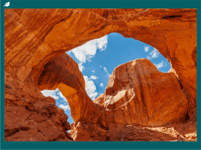
Double Arch, a short detour from the Windows parking area, is exactly what it says: two arches sharing a single base, with the larger one spanning 148 feet and standing 112 feet tall. Walking beneath it and looking straight up through the opening to the sky is a pure, uncomplicated moment of awe. It takes about 15 minutes from the trailhead. Worth every one of those minutes.
The Courthouse Towers area near the park entrance, with formations like the Three Gossips and Sheep Rock rising dramatically from the desert floor, rewards drivers on the main scenic road even if they never leave the car. But leave the car. Every time. The scale only makes sense on foot.
Arches national park is worth two full days if your schedule allows it. One day for Delicate Arch and the Devils Garden loop. A second half-day for the Windows Section, Double Arch, and the Fiery Furnace if you’ve secured permits. The park road is 18 miles from entrance to Devils Garden trailhead, with multiple viewpoints and pullouts along the way that turn even the drive into its own kind of adventure.
Capitol Reef: A Hidden Gem
Capitol Reef national park is the quietest of the Mighty Five. Fewer visitors, less infrastructure, smaller crowds at the trailheads. That’s not a flaw. It’s precisely what makes the place so good.
You get to be somewhere genuinely remote and spectacular without fighting for parking.
The park sits in south-central Utah, about 125 miles east of Bryce Canyon on Highway 24. The drive in from the west takes you through increasingly dramatic country, red cliffs rising on either side of the highway as the landscape narrows and intensifies. By the time you reach the park boundary, you’re already in it.
What Makes Capitol Reef National Park Unique?
The defining geological feature of capitol reef national park is the Waterpocket Fold, a monocline: basically a single-sided flexure in the Earth’s crust where rock layers on one side sit dramatically higher than on the other. This one runs for nearly 100 miles through the park, creating an enormous wrinkled wall of exposed rock layers that represent nearly 270 million years of geological history. Every stripe of colour you see in those cliffs, white Navajo Sandstone above, red Wingate Sandstone below, purple and chocolate Chinle Formation further down, represents a different era, a different environment, a different chapter in a story the planet has been writing for a very long time.
The name “Capitol Reef” comes from the white Navajo Sandstone domes that early explorers thought resembled the US Capitol building, combined with the reef metaphor for a rock barrier impassable to wagons. Both elements still make sense when you see the landscape.
Cathedral Valley, in the park’s remote northern section, is accessible by high-clearance vehicle and rewards the effort with an otherworldly landscape. Enormous sandstone monoliths called Temple of the Sun and Temple of the Moon rise from the flat valley floor, isolated and improbable, reaching heights of 400 feet. At sunrise or sunset, when the light catches them at low angles, they look genuinely sacred. A trip into cathedral valley requires planning: 58 miles of dirt road, a river ford at Hartnet, and no services whatsoever.
The Fremont people left their mark on Capitol Reef in the form of petroglyphs carved into the dark desert varnish on cliff faces near the Fruita Historic District. The panels along Utah Highway 24 near the park visitor centre are extensive and well-preserved, showing human figures with elaborate headdresses, bighorn sheep, and abstract designs created between roughly 600 and 1300 CE. Standing in front of those panels, touching the same air that people breathed a thousand years ago, gives you a specific kind of vertigo. This canyon wasn’t empty before Europeans arrived.
It was someone’s home.
The Fruita Historic District tells a more recent story. Mormon pioneers settled here in 1880, attracted by the permanence of the Fremont River, and planted orchards that are still producing fruit today. The National Park Service maintains nearly 3,000 fruit and nut trees in Fruita, and during harvest season (typically June through October depending on the variety), visitors can pick their own fruit for a per-pound fee set by the park. Cherries, peaches, pears, apples, apricots.
In the middle of canyon country. It’s one of those details about capitol reef that stops people short when they hear it for the first time.
Hiking trails in Capitol Reef range from the easy Capitol Gorge walk (2 miles round trip through a narrow canyon past pioneer signatures carved into the rock walls) to the more demanding Cassidy Arch trail (3.5 miles round trip with 670 feet of elevation gain to a natural arch with panoramic views of the surrounding canyon country). The Hickman Bridge trail, a 1.7-mile loop, climbs to a natural bridge spanning 133 feet and offers views back toward the Fruita valley and the white domes of the Capitol formation. It’s one of the best short hikes in the park, accessible to most fitness levels, and underrated compared to similar trails in more famous parks. If you want to hike something off the beaten track entirely, the Strike Valley Overlook trail in the southern Waterpocket Fold section rewards the extra effort with views across the fold’s corrugated ridgelines that almost nobody else is standing on when you get there.
Capitol reef also earns designation as an International Dark Sky Park, one of many in Utah. The Milky Way over the desert here, with no city light within 50 miles, is staggering. If you’ve ever wanted to see a sky so dense with stars it looks more solid than dark, this is the place. The park’s location, far from Powell Lake’s recreation corridor and any sizeable town, keeps light pollution genuinely minimal.
Bring a blanket. Look up. The park offers ranger-led stargazing programs at the visitor centre amphitheater during summer and fall, and even without a program, the stars alone are reason enough to stay the night.
The thing about Capitol Reef is that it asks you to slow down. The other parks in the Mighty Five can feel like you’re trying to consume as much scenery as possible before time runs out. Capitol Reef rewards a different pace. Sit by the Fremont River.
Unveiling the Surreal Landscapes of Canyonlands
Canyonlands national park covers 337,598 acres of southeastern Utah, making it the largest of the five Utah national parks in the Mighty Five circuit. The Colorado and Green Rivers carve through the middle of it, and the land between and around those rivers is divided into three distinct districts: Island in the Sky to the north, the Needles to the southeast, and the Maze to the west. Each district is separated from the others by the river canyons themselves, meaning you can’t drive between them. Each one requires its own approach road and its own mindset.
Most visitors focus on Island in the Sky, a broad mesa that sits 2,000 feet above the surrounding canyon country and offers viewpoints that genuinely redefine your sense of space. Mesa Arch, a short half-mile loop from the trailhead, frames the canyon below through a sandstone arch that catches the first light of sunrise in a way that photographers line up for hours to capture. Get there 45 minutes before sunrise. Stand near the back of the crowd if you’re not a photographer.
Watch the light travel across the canyon below.
Grand View Point, at the southern tip of Island in the Sky, looks out over 10,000 square miles of canyon country. Ten thousand square miles. On a clear day you can see mountain ranges in Colorado and the La Sal Mountains above Moab to the east. The viewing area has a short rim trail that offers multiple perspectives along the edge.
Adventure Activities in Canyonlands
The White Rim Road is the park’s most famous mountain biking and 4WD route: a 100-mile dirt road that loops around the Island in the Sky mesa at the intermediate terrace between the top and the river below. It typically takes three to four days by mountain bike or two days by high-clearance 4WD vehicle. Permits are required and competitive. The route passes through some of the most remote canyon scenery in the park, with campsites accessible only by permit and no services whatsoever once you’re on the road.
For experienced mountain bikers who want an epic, multi-day backcountry cycling adventure, this is one of the best routes in the country.
White-water rafting on the Colorado and Green Rivers offers a completely different relationship with Canyonlands than you get from the rim. Guided commercial trips operate through Cataract Canyon, which begins just downstream of the rivers’ confluence inside the park. Cataract Canyon contains some of the biggest white-water rapids in North America, with flows at their most powerful during spring snowmelt. Multi-day rafting trips through Cataract Canyon give you the canyon walls from water level, looking up at formations you’d otherwise only see from 2,000 feet above.
It’s a transformative perspective. The confluence of the Colorado and Green Rivers, visible from the Confluence Overlook trail (10 miles round trip from the Needles district), is one of the park’s most sought-after viewpoints, and the rafting trips pass through it at river level.
Hiking in the Needles district, named for the coloured sandstone spires that dominate its skyline, offers a different texture than Island in the Sky. The terrain here is lower and more intimate, with trails threading between the red and white banded spires through grasslands and slot canyons. The Chesler Park trail, about 6 miles round trip to the open meadow surrounded by needles formations, is one of the best hikes in the district. The Joint Trail section, where the path squeezes through a narrow crack barely shoulder-width wide, is the kind of canyonlands experience that gets remembered and retold.
For those who want to experience the most extreme version of canyonlands adventure, the Maze district is out there. It requires a high-clearance 4WD vehicle just to reach the trailhead, and once you’re in, route-finding through the labyrinth of canyons uses topographic maps, cairns, and judgement. It’s not a place for casual visitors. It’s a place for people who genuinely want to be tested by terrain.
The Harvest Scene pictograph panel in the Maze, a large collection of ancient rock art, is among the most impressive in the entire Colorado Plateau. Getting to it is most of the point.
The interplay of light on the canyon walls changes throughout the day in ways that make Canyonlands worth staying for multiple sunrises and sunsets. The colours at dusk, when the shadows deepen in the canyon systems and the mesas catch the last orange light, shift every few minutes. It’s not static. The park keeps moving on you, which is part of why it rewards longer visits.
Plan at least one full day in Canyonlands. Two is better. Three, if you’re doing the White Rim or a rafting trip. This is not a park to drive through and photograph from the viewpoints, though the viewpoints are extraordinary.
It’s a park that reveals itself progressively, one canyon wall at a time.
Exploring the Unique Geology and Colors of Bryce Canyon
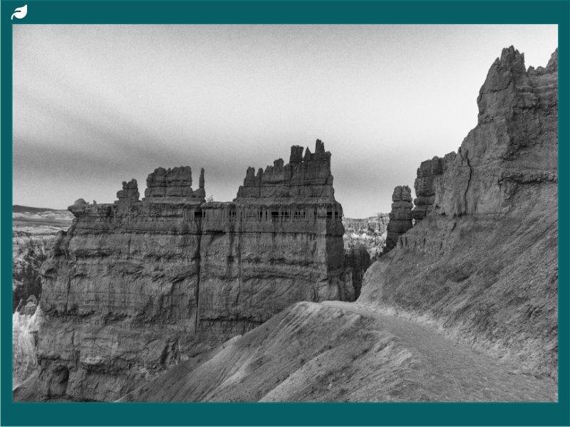
Bryce Canyon is not actually a canyon. It’s worth leading with that because it changes how you understand what you’re looking at. The park sits on the edge of the Paunsaugunt Plateau in southwestern Utah, and what erosion carved here isn’t a river gorge but a series of horseshoe-shaped natural amphitheaters along the plateau’s eastern edge. The Pink Cliffs formation, made of softer limestone and siltstone than the sandstone that dominates other Utah parks, erodes in a specific way: frost wedging cracks the rock repeatedly through the freeze-thaw cycle (Bryce Canyon averages 200 freeze-thaw cycles per year), and the result is hoodoos.
There are more hoodoos in Bryce Canyon than anywhere else on Earth.
A Walk Among the Bryce Canyon Hoodoos
Standing at the rim of Bryce Amphitheater and looking down into the forest of hoodoos below is one of those experiences that triggers a genuine recalibration. The hoodoos range in height from 5 to 200 feet, and they pack so densely into the amphitheater that the overall effect is somewhere between a crowd of figures and an eroded city. The colours, banded red, orange, pink, yellow, and white, come from iron and manganese oxides in the rock. At sunrise, when the light comes in low and warm from the east, the whole amphitheater appears to burn.
Sunrise Point and Sunset Point are the two main rim viewpoints at Bryce Canyon national park, and both are connected by the Rim Trail, which follows the plateau edge for 11 miles total. The short section between Sunrise and Sunset Points, about 1 mile along the rim, gives you continuous changing views down into the amphitheater from slightly different angles. Walk it in both directions at different times of day, and it’s a genuinely different experience each time.
The Navajo Loop Trail descends from Sunset Point into the amphitheater through a narrow canyon called Wall Street, where hoodoos crowd the path on both sides and Douglas firs grow 80 feet tall in the confined space where water collects. The trail loops through Thor’s Hammer, one of Bryce Canyon’s most photographed formations, before climbing back to the rim. At 2.9 miles round trip with 550 feet of elevation change, it’s manageable for most hikers and delivers everything that makes Bryce remarkable: the descent into the hoodoos, the scale shift once you’re among them rather than above them, and the way the canyon walls close in until you’re walking through something that feels like geology’s own architecture.
The Queens Garden Trail connects to the Navajo Loop via a connector path, allowing you to combine both into a 4-mile loop through the heart of the amphitheater. The Queens Garden section is less steep, taking a more gradual descent through hoodoos to a garden-like basin named for a formation resembling Queen Victoria. The combined loop is the single best introduction to Bryce Canyon hiking. If you only have a few hours in the park, this is how to spend them.
For a longer and more remote experience, Peekaboo Loop covers 5.5 miles through the southern section of the amphitheater, passing the Wall of Windows and the Cathedral formations with sustained hoodoo views throughout. The trail is also open to horses, and the sight of riders moving through that landscape at the same pace the terrain demands feels historically appropriate, since the plateau was named for Ebenezer Bryce, a Mormon pioneer who grazed cattle here in the 1870s and described it as “a hell of a place to lose a cow.”
Bryce Canyon’s elevation, between 8,000 and 9,100 feet at the rim, means the atmosphere is noticeably thinner than at Zion or Arches. Hikers coming from lower elevation parks should expect to work harder for the same distance. Drink more water than you think you need. Take the descents carefully on loose trail sections.
And give yourself time to simply stand at the rim and look, because the views keep changing as the sun moves and the shadows in the amphitheater shift. Bryce Canyon rewards patience as much as it rewards effort.
Winter in Bryce Canyon is spectacular in a completely different way. Snow settles on the hoodoos and emphasises their shapes, the orange and white contrast deepening dramatically. Cross-country skiing and snowshoeing are permitted on certain trails, and the park stays open year-round. If your road trip happens to fall between November and March, don’t assume Bryce Canyon is off the table.
It’s one of the best times to visit.
Planning Your Bryce Canyon Days
One full day at Bryce Canyon national park is the minimum. Two days lets you do the rim properly on day one and descend into the amphitheater on day two. The park road extends 17 miles south of the main amphitheater to Rainbow Point, the highest elevation in the park at 9,115 feet, and the drive south along the rim passes Natural Bridge (a natural arch, confusingly), Agua Canyon viewpoint, and Ponderosa Canyon with sweeping views at every stop.
Accommodation at and near Bryce Canyon includes the Bryce Canyon Lodge, the only hotel inside the park, and a range of motels and cabin rentals in Bryce Canyon City just outside the entrance. Ruby’s Inn, a large motel complex just north of the park, operates its own campground and horse riding tours. The Best Western Plus at Ruby’s Inn is useful as a base for exploring the park over multiple days. Camping inside the park at North Campground or Sunset Campground puts you close to the rim trailheads, with reservations through recreation.gov essential for spring and summer visits.
The shuttle system at Bryce Canyon runs seasonally and connects the visitor centre to the main viewpoints and trailheads along the north section of the park road. Using it is faster and easier than driving between viewpoints during busy periods, and it reduces the parking stress that can otherwise eat into your hiking time.
Bryce Canyon sits roughly midway between Zion and Capitol Reef on the standard Mighty Five road trip route, making it a natural two-night stop. The park rewards the time. It’s the most visually distinctive of all five Utah national parks, and it’s the one that most often produces the response: “I had no idea this existed.” Now you do.
Practical Tips for Your Utah Mighty Five Road Trip
A week is enough to see all five Utah national parks if you plan it carefully, but the word “see” covers a wide range of experiences. Five days of driving and single-day stops gets you a taste. Seven to ten days, with two nights in Zion and two nights based in Moab for both Arches and Canyonlands, gets you something more substantial.
The standard anticlockwise loop starts in Zion, heads north and east to Bryce Canyon, continues east to Capitol Reef, loops south and west to Canyonlands and Arches near Moab, then returns west. Total driving is roughly 800 miles. The drives themselves are scenic and worth doing in daylight, particularly the route through Capitol Reef on Highway 24 and the descent into Moab on US-191 with the canyon walls rising on both sides.
The America the Beautiful annual pass (currently $80) covers entrance fees for all five parks and pays for itself within two park visits. It’s the single best value purchase for any Utah national parks road trip. Buy it at the first park entrance station you reach.
Cell service is limited or nonexistent in most of the parks and on many of the drives between them. Download offline maps (Google Maps and Maps.me both work) before you leave the last town with reliable service. Download the individual NPS apps for each park. Carry physical backup maps for anywhere you’re hiking off maintained trails, particularly in Canyonlands and Capitol Reef.
Water is the non-negotiable. The desert is dry, the elevation is high, and the hikes are exposed. Carry a minimum of two litres per person for any hike over two miles. Refill at visitor centres and campgrounds.
Don’t rely on finding water on trails unless the trail description explicitly lists water sources. That applies whether you’re doing a casual morning hike at Bryce or a full-day push into the backcountry at Canyonlands. The moment you underestimate water in the Utah desert, you’ll feel it in ways that ruin an otherwise extraordinary day.
Spring (April to May) and fall (September to October) are the best times to visit. Summer brings crowds and serious heat, particularly at Zion and Arches where canyon temperatures can exceed 100 degrees Fahrenheit by midday. Winter closes some facilities and makes higher-elevation roads at Bryce Canyon and Capitol Reef occasionally impassable, but the parks are quieter and often genuinely beautiful in snow.
Book accommodation as far in advance as possible for spring and fall. Zion Lodge and Bryce Canyon Lodge both sell out months ahead. Campground reservations for Watchman, North Campground, and the Devils Garden campground at Arches open six months in advance on recreation.gov. If you’re doing this trip in peak season without accommodation booked, Moab has the most hotel options and the most availability, but even Moab fills up on weekends from March through November.